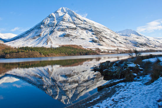
Crummock Water and Lanthwaite Wood is a great family walk in the Lake District.
Recommended Map: Explorer OL4
Buy here to support our Free Walk Guides
Buy OS Explorer OL4 The English Lakes – North Western area (OS Explorer Map)
| Difficulty Rating:
Family Walk Danger Rating: |
Time to complete: About 1.5 hours
Distance: About 5 km (3 miles) |
Car Parking/Walk Start:
Lanthwaite Wood at the northern end of Crummock Water, in between Loweswater and Scale Hill Holiday Cottages. |
Overview of Walk:
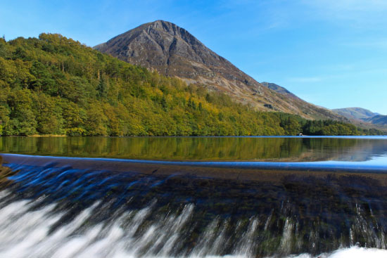
Crummock Water lies in between Loweswater and Buttermere in the North West Lakes. This walk is an easy family outing with very little climbing involved. There’s high mountain scenery, red squirrels, lakeside walking, homemade swings and stunning views; a great way to enjoy an afternoon outing with the family.
| Refreshments:
Kirkstile Inn, Loweswater; also facilities in Lorton and the Lorton Vale. |
Wheelchair and Push Chair Suitability:
From start of walk to point “A” keeping to the forest tracks shown in pink. |
Public Transport:
Bus 77/77A Keswick/Lorton (stops on B5289, midway point of the walk). |
Walk Description: Crummock Water and Lanthwaite Wood
From the car parking area, follow the forest track through Lanthwaite Wood in a south easterly direction, ignoring tracks off to the left, and descending down to the shores of Crummock Water. Keep your eyes open for red squirrels.
From the lakeshore, take a path uphill in an easterly direction. It quickly intersects the forest track and you continue on in a south/south easterly direction above the lake.
Just before a boat house, take the path on your left uphill through the woods. Keep on the path and you come to a forest track as it descends to a field. Enter the field and walk in a north easterly direction following the stone wall on your left. In front of you, you have the awesome sight of Whiteside and Grassmoor, two of the largest mountains in the North West Lakes. At the end of the field, go through a gate and turn right following the track as its swings to the left and heads uphill towards the B5289.
Cross over B5289, taking the farm track in northerly direction. You join a stone wall on your left and take the path on the right for the “Fell and Bridge”. You soon reach Liza Beck, the scene of devastation in November 2009, when Cumbria flooded. We’ve done this walk several times since and the footbridge which was destroyed still awaits repair; however, another footbridge can be used a little further upstream.
Follow Liza Beck uphill until you reach a (useable) footbridge. Once over the footbridge follow the beck back downstream heading through gorse bushes. When you reach a stone wall, bear right and follow it as it turns and heads in a northerly direction. When the path splits head down closer to the wall.
Eventually, you come to a gate in the stone wall: go through it and down the steps; keeping close to the stone wall on your left as you head down through the field. Continue on and use a new footbridge, then over the B5289, going through the gate on the other side of the road (Public footpath to Scale Hill). You are now following a stone wall on your right.
Follow the path over a stone stile, through further fields, keeping close to the fence, then stone wall, on your right, and past old oak trees. Go over a small footbridge/stile and head uphill steeply through the woods at Tindle Crag. Turn right when you reach a faint forest track, another faint forest track is seen almost immediately, bear left onto a narrow footpath and within a few seconds you descend over a wall and join the Loweswater / Lorton road. Take a left here, taking care as you walk up to Scale Hill. Ignore the footpath on your left and descend steeply down the road to the River Cocker. Just before the bridge, turn left into the car park at Lanthwaite Wood.
Rate this walk
based on 3 reviews.
Rate this: Select a rating: 5 Stars (Best) 4 Stars 3 Stars 2 Stars 1 Star 0 Stars (Worst)
0 = worst; 1 = disappointing; 2 = average; 3 = a really good walk; 4 = I recommend this walk; 5 = one of the best walks I’ve done
| Visit our shop! Here’s a selection of products you might find useful in this area of the Lakes: |
| Compass; Navigate with ease; Magnifier; Great value essential product |
Wainwright’s Book 6: “The North Western Fells”; (updated in 2008 by Chris Jesty) |
Ordnance Survey Map OL4 : The English Lakes: North-Western Area Map | Keswick, Cockermouth & Wigton |
Whilst we try our very best to ensure the accuracy of this information, we accept no liability for anyone getting lost or injured. You should always consult your ordnance survey map for exact details and wear appropriate clothing for the weather conditions.